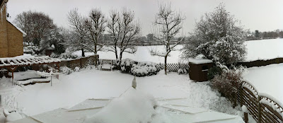
Sunday, 26 December 2010

Bitterly cold Christmas.. but will December be a record breaker?

Christmas day dawned overcast and cold with a temperature of -4.7 achieved in the small hours. A white Christmas of sorts as the low overnight minima has helped preserve the slowly thawing snow cover, picture post-card? no but better than mild and wet.
So on to Boxing day and yet again a hard overnight frost of -7.4 has left a thin cover of ice over the fish pond, the first time its ever frozen over but this is due to the pump being turned off as the filters are still frozen from the -13.1 last week!
The mean temp for Hawley for December is currently -0.4, a sub zero month would be a record but with milder winds set to extend east across the UK this is under threat, unfortunately.
Pond after a -13.1 night!

So a potentially messy breakdown is on the cards, into January and its difficult to predict what will happen with the weather, this winter so far has been exceptionally cold and has generally fought off any mild incursions from the West, this can't last of course but with three potentially very cold months before the spring anything is possible.
I mentioned some weeks ago that 'the beast from the east' wants to come and party at new year, well he may be a week late but I'm confident that another cold spell is going to hit us by the second week of Jan.
Boxing day Ice cover
Keep those snow shovels handy...

Saturday, 18 December 2010

Sat 18th snow update

As I was writing my previous blog snow began to fall heavy and lasted for about an hour and gave an inch of snow.
Struggling to get into work now due to the absolute chaos on the roads, you might ask why? As it's only an inch! ( you can do much with an inch..)
Here's the answer: last night was bitterly cold with temperatures well below freezing, the snow that has fallen has fallen onto frozen roads turning instantly to ice not slush as cars run over the snow.
who's to blame for this carnage?
The council failing to grit of course but it's not quite that simple as grit/salt loses it's effectiveness the colder it gets.
Good job Santa uses reindeers and a sleigh eh!!


- Posted using BlogPress from my iPhone

Christmas Shopping Chaos

Snow again returned to the UK yesterday with large parts of the country having significant accumulations.
As for us here in Hawley, just a dusting in the afternoon but coupled with plummeting temperatures (-9.1) as the sky cleared made for awful walking and driving conditions.
yesterdays covering with more forecast today.


This weekend is the last and biggest weekend for Christmas shopping and the weather gods are clearly with the coalition and is forcing all shoppers to tighten their belts! Its not a day to be out shopping as much more snow is falling today across southern/central Britain causing associated travel chaos.

So as we head in to Christmas week things continue to be cold with more sleet/snow possible almost anywhere but as we head towards the big day mild air will prevent a 'white' Christmas.. but watch out at new year, the 'Beast from the East' wants to come and party..

Tuesday, 14 December 2010

More disruption this week as snow returns

After spending 3 days in a bitterly cold Berlin I flew back last night to a much 'greener' UK with most of the snow melting in the above zero temperatures of the last week with just some dirty slushy mounds still holding on for grim melt.

But its about to get colder again, much colder.

Its fairly certain that we are locked into a blocking pattern of weather that is keeping the door shut on the Atlantic and the UK cold as Arctic air is pulled from the north, but there will be incursions of milder, wetter weather  from the west but they will be short lived, however when Atlantic lows do move in a battleground develops where the milder air meets the cold air already here.

The fun starts on Thursday when a band of rain heading south but behind it, driving this front forward, is extremely bitter Arctic air, so what initially starts as rain will turn to snow and  many places will get disruptive accumulations.  Into the weekend and early next week an Atlantic low will run into colder air over the southern half of the UK and this kind of mild meets cold scenario can deliver epic snow for the lucky (or unlucky depending on your viewpoint) and this type of meteorological frolicking looks sets to continue as we head towards Christmas day.

So travel Chaos in the run-up to Christmas is a distinct possibility for many parts of the country, I wouldn't trust ordering presents online! but are we in for a white Christmas? well we have our best chance for years but as I have mentioned in previous blogs my view is that mild air will wreck that particular dream.

Winter victims
it had survived 11 winters, but not this one
After removing my pond netting today this is what I discovered.


this poor bird got under the netting for a drink from
running water and drowned getting out...
Bird Brain

Tuesday, 7 December 2010

Winter set to tighten its grip-next week

A week on from the first snow of the three day snow event in Kent and the country is still in the grip of this historic early winter blast.
More heavy snow has wreaked havoc in Scotland with hundreds of motorists trapped in their cars on motorways for 15 hours!
country tracks..
Here in Hawley I recorded another ice day yesterday with another possible today. Minor roads are still covered in thick ice and the fields deep with lying snow.
So as we head toward the weekend we should see a gradual lift in temperatures during the day unless freezing fog lingers, with the warmest day probably Saturday.
Sunday heralds a new week and a renewed blast of Arctic air especially for the North and East, so is more snow on the horizon? well that depends on what direction the air is coming from if its from the North then it should be dry, from the East or North-East then it is definitely possible.
So December is shaping up to be an historic month temperature wise with deep cold possible right up to and including Christmas and new year, quite  unprecedented!

icy tracks

Sunday, 5 December 2010

Bitterly cold week ahead

As the country struggles through the dirty, tarnished slush and gets back to some sort of normality, the brief mild spell of the last few days is set to be replaced by low daytime temperatures and biting night time severe frosts, although the week ahead will be dry, so no more snow!
As we head into next weekend temperatures shall again rise and should melt any lying snow but this brief warm up will be short lived as plunging temperatures and the risk of more snow especially in the east, sets the scene for what could be a snowy run -up to Christmas.
So a record breaking December is on the cards but will this lead to a milder than average January?


- Posted using BlogPress from my iPad

Friday, 3 December 2010

Bitter, Frigid Cold

Last night I recorded my lowest ever temperature since I started keeping records 5 years ago, a bone chilling -10.6C!
My previous record of -8.4C was set in January this year so is winter 2010/11 going to eclipse 2009/10?
It has so far for snow with this significant early snow event and you have to say that with no real end in sight to this cold spell ( apart from the next two days of 'normal' temps) the odds are that this winter will be colder than last, are we now in a run of successive cold winters? I certainly think so, wait until next winter!
after a night at -10.6
This afternoon I took Kimi for a walk over the fields behind my house, what a beautiful winterscape it was, eery in its quiet, cold, all consuming white blanket. A truly spectacular experience.
I left my house at 16:15 and the temperature was -4.9, when I returned home just 30 mins later it was -6.7!
I was hopeful of breaking last nights record and after getting to -8.4 at 16.30 clouds from the west have scuppered my hopes (unfortunately)

lonely tree
Panoramic view of the field at the back of my house


Another view


Thursday, 2 December 2010

I'm dreaming of a white.....

Another day, another dumping of the white stuff, and respect to the snow Gods, this is premium snow!
Today looks set to be the second consecutive 'ice day', actually the temp has been much below freezing all day so its a MEGA ice day!
At 1pm today I measured 11.5 inches of level snow on my lawn and with the snow coming down heavy as I write I should be over 1ft by now, truly an exceptional snow event.
a foot of snow..
Doing his bit for Royal Road

Once fuelled with a bacon and egg sarnie I ventured out with my small Panasonic Lumix camera to get some shots of the local area where I like to walk the dog. This fine chap on the right was helping the residents get on to the Hawley road.


Wintry


The temperature at the time of my walk was minus 1.8C, so I wasn't out for long, I did consider popping into the pub but it was a bit too early, even for me!
Chequers Pub, nice in the summer.


So Am I dreaming of a white Christmas? depends really, in the betting sense no, but I'm willing to wager that some of this snow will still be around on the 25th... because nothing is warming up too much in the foreseeable future!


So take care all and should we get some less cold days, there won't be many and the 'Beast from the East' hasn't finished with us yet!

Ciao
Panoramic view from my bedroom window
(iphone4)


Wednesday, 1 December 2010

The morning after the day before!

Yesterday's huge snowfall event across the SE reminds me of the snowy winters we had in the 80's!
I was so concerned about the weight of the snow on my conservatory roof that I got it all off with a huge broom, it was sliding off the roof in big 6 inch thick slabs, I could have build an igloo with them!

7 inches of snow on the Mini


Anyway onto today and light snow is still falling and will probably be like this all day, tonight could be interesting with a low pressure system bringing milder air in from the south, and is currently giving heavy snow to the snow starved south coast as it bumps into the entrenched cold over the UK.
If this system tracks north then the SE could again be in for some more heavy snow tonight and tomorrow.

My frozen Anenometer

Tuesday, 30 November 2010

Winter Wonderland!

Overnight the snow gods duly delivered here in Kent, I had a sneak peek out of the window at 4am and saw I had a covering and thats all I thought I was getting, how wrong was I!

Its been snowing continuously since I got up at 7.30am and the forecast is for yet more later on today, I have to say that this event has exceeded my expectations and was certainly worth waiting for.

There is a good probability now that a breakdown in the cold is on the cards for next week but don't expect it to be mild, just less cold, the country after-all has been frozen for some 10 days and that it will take time for milder air to win through.
I mentioned in a previous blog if this unusual, extreme early spell of winter is the harshest we will have during the winter of 2010/11? I certainly don't know but its worth remembering that the official start of winter is not until tomorrow, we are still in Autumn!


As a cold weather fan I can't join the naysayers in their pessimism of what Dec, Jan and Feb may hold, I do think though that If you've put some hard earned cash on a white Christmas then you have most certainly lost your money!

Monday, 29 November 2010

Tonights the night!

Well finally we are going to get snow tonight, it's due to start snowing anytime now and should last all night giving some good accumulations, especially on higher ground.
So if you're travelling tomorrow check the travel advice and stay safe and warm!
Ciao


- Posted using BlogPress from my iPhone

Sunday, 28 November 2010

It's almost here!

I'm confident now that the SE will see some decent snow over the next 3/5 days with significant accumulations possible in favoured locations.
A few light flurries have arrived this evening and things are going to turn really interesting in the coming days!


- Posted using BlogPress from my iPhone

Brrrrrrrr!

Recorded minus 7.7 last night and only missed my first ice day by 0.1C! Congratulations to Gav in Rochester who got his one and only notable weather stat with an ice day (just)
Today was slightly warmer during the day and as I now cloud cover temps won't be as low tonight.
The forecast is to remain very cold this week with perhaps widespread snow for the south and south east.

My car at 22.15, temp then was -4


- Posted using BlogPress from my iPhone

Saturday, 27 November 2010

Brrrrrr!

As most of the country comes to terms with the recent snows the lucky ones are preparing for much more.
What about us here? Well it's very very cold which is the main ingredient but largely dry.
Snow showers could pop up at any time but I'd be surprised if we got any more than a slight dusting over the next 2-3 days.
Still, with the forecasting models not great for Kent I'm remaining optimistic, esp toward the end of the working week...

A timely reminder that its still Autumn!


- Posted using BlogPress from my iPhone

Jack's back!

Yep, Jack Frost returned last night and he was in a serious mood! Recorded a low of -5.5 and the rate at which the temperature dropped after sundown was amazing!


- Posted using BlogPress from my iPhone

Thursday, 25 November 2010

Winter arrives

The earliest widespread snowfall in 17 years hit Scotland and NE England today bringing the usual disruption that can only happen in the UK!
So far Kent has been dry due to the North Westerly winds keeping any showers from penetrating inland, but this could change with the wind forecast to
swing to a NE direction tomorrow although my view is that we would be lucky to see any lying snow this weekend.
But at this stage there is moderate confidence that a low pressure system currently in the Bay of Biscay may bring widespread heavy snow to the south early next week, but, as we know, that is a long way off in meteorological terms.
So the cold is set to last for another 7-10 days, a warm-up is inevitable at some point but current Synoptics favour a re-load of colder conditions pretty soon after!
Interesting times await...


- Posted using BlogPress from my iPad

Tuesday, 23 November 2010

Winter set to arrive....in style.

As I write this blog much colder air is seeping down from the north east and is set to intensify over the next 5 days or so bringing increased snow risk to south East England as we head toward the weekend....but it doesn't end there.
Another low dragging even colder air with it threatens to deliver widespread snow to even lower levels in all parts of the south and it could, very possibly, snow right through until Tuesday of next week bringing widespread chaos and disruption.
Biblical? Epic? For some, very possible. Question is, will this be our only shot at snow this winter?

Surely this map is the Holy Grail of winter!


Map shows possible snow coverage.


- Posted using BlogPress from my iPad

Saturday, 20 November 2010

Snow for some, severe cold for all..

It's nailed on now that the UK is going to get a serious taste of winter, just three short weeks after achieving 19 degrees. How things can change!
The question is, as always, where will the snow fall? In my mind there is no doubt that parts of the country will have significant accumulations and others nothing,... you feeling lucky (punk)?
As we are a small maritime country, minor changes in the jet, trajectory of shortwaves and the position of the atlantic lows can have a massive affect on where the flakes fall, but, and take the warning.. It's going to turn bitterly cold with severe overnight frosts and possible 'ice days'
So, to sum up, for cold lovers the future's bright, the future's


White?

- Posted using BlogPress from my iPad

Wednesday, 17 November 2010

Winter in waiting?

It now looks odds on that a change to much colder weather is on it's way, obviously British Gas employ their own, clearly very good weather geeks, and have put their gas prices up!
Anyway the question is "will it snow"? my view is that it is unlikely although east Coastal areas stand a better chance but any snow in Kent or Essex will be of flurries only, but I would love to be proved wrong!
The map below is what's called a 'Cobra' run but I won't explain that yet...


- Posted using BlogPress from my iPad

Tuesday, 16 November 2010

Fog and Frost

After tomorrows low pressure system has dumped it's rain over southern Britain the weather looks to be moving from typical Autumn to unusual early winter.
Frost and fog will feature strongly from this weekend with some tantalising prospects for cold weather fans after that. Stay tuned!


- Posted using BlogPress from my iPhone

Sunday, 14 November 2010

Rememberance Sunday

Dark, dank, wet and miserable day as the dreary zonal weather continues, not the best of days for the Cenotaph ceremony.
Still, looking at the height anomaly charts things could become very interesting soon.


- Posted using BlogPress from my iPhone

Friday, 12 November 2010

The morning after the day before!

The deep low certainly caused a few problems yesterday, wind speeds of 50-60 mph caused structural damage and traffic chaos with the closure of the Dartford bridge.
Today should be much quieter before more rain showers at the weekend. Interesting stuff.


- Posted using BlogPress from my iPhone

Thursday, 11 November 2010

Atlantic Attacks!

After a quiet and cold day yesterday, today see's a deep low move west to east bringing strong winds and lots of rain.
Height rises over Greenland hint at a change to drier and colder conditions in a week or two, but with an Atlantic loaded with energy as it often is in November will the cold win out?


- Posted using BlogPress from my iPhone

Tuesday, 9 November 2010

Proper Autumn

Very wet and windy for the forseable, autumn always brings the most diverse weather, and no end in sight for at least two weeks according to medium range forecasts.


- Posted using BlogPress from my iPhone

Sunday, 7 November 2010

The best winter pastime?

When will the serious sport of lamp post watching start??
Probably this weekend on the hills of northern Scotland, but for us soft (shandy drinking) southerners all we have to look forward to in the short term is gale force winds and lashings and I mean lashings, of cold November rain!


- Posted using BlogPress from my iPhone

Saturday, 6 November 2010

That's more like it

After double digit nights, the temperature has dropped to what you'd expect for a November evening. This photo of Matt's car was taken at 10pm at Asda Swanley when just below 3 degrees


- Posted using BlogPress from my iPhone

Bonfire night

The weather was mild, the breeze had gone and as did the rain. Warmest bonfire night I can remember@ 15 odd degrees!


- Posted using BlogPress from my iPhone

Thursday, 4 November 2010

Leaves


- Posted using BlogPress from my iPhone

Location:Chequers pub

Crazy British weather

It's probably not often that you can walk about in just a t shirt in November, considering we hit -3.2 a few weeks back today it's 18 degrees! Lots of nice colour on the tree tho and the leaves have really dropped in the last few days. Been very windy today which probably helps!


- Posted using BlogPress from my iPhone

Saturday, 30 October 2010

Still mild

Above average temperatures again for this coming week, I wonder if these ducks are in for a hard winter, doesn't look like it yet!


- Posted using BlogPress from my iPhone

Wednesday, 27 October 2010

Wow

17.8 degrees achieved here today, wow!


- Posted using BlogPress from my iPhone

Location:Home

A respite from the cold

After some cold and wet weather, today has been fantastic with warm westerlies nudging the temperature up to 16 degrees! Can't argue with that in late October.
Trees are all showing nice colour now, should be spectacular in the next few weeks or so!


- Posted using BlogPress from my iPhone

Tuesday, 26 October 2010

Wet and cold evening in London


- Posted using BlogPress from my iPhone

Rainy and sort of cold

Just about to leave home to get train to London.
Plenty of rain about and a little breezy, is my light leather jacket enough? Suppose 'the smoke' should be a tad warmer than Hawley.


- Posted using BlogPress from my iPhone

Monday, 25 October 2010

Cold morning


Another sub zero night


- Posted using BlogPress from my iPhone

Sunday, 24 October 2010

Nasty clouds

It's cold tonight and very wet, don't like the look of those clouds!


- Posted using BlogPress from my iPhone

Friday, 22 October 2010

Warmer evening walking the dog, amazing how much you can see in just moonlight, mind you I'm pleased that Border Collies have a White tip on their tails!


- Posted using BlogPress from my iPhone

Location:Dartford,United Kingdom

Thursday, 21 October 2010

FI

First frost of the autumn this morning, and it was a hard frost too, -3.3 which was a surprise!
But it soon warmed up as the sun still has plenty of warmth at this time of year.


- Posted using BlogPress from my iPhone

Location:Royal Rd,,United Kingdom

Sunday, 17 October 2010

Very cold watching a footy match in Dartford this evening, the first taste of what could be a harsh winter?


- Posted using BlogPress from my iPhone

Location:Royal Rd,,United Kingdom

test

test